
December 31, 2008
Non-Standard Roadsign Colors
November 15, 2008
Sights in the Arbuckles

Turner Falls in Oklahoma's Arbuckle Mountains
The Arbuckle Mountains are a very old range of mountains located between Davis and Ardmore, Oklahoma. This uplift is somewhere around 500-million years old. Today, Interstate 35 makes them almost unnoticeable, but old US 77 wound around for a few miles through these hills. They are so old and so worn that they are no longer mountains in the sense of the Rockies or even the Appalachian range. Still, they are quite beautiful, and home to the Arbuckle Wilderness and Turner Falls, pictured above. Turner Falls is a 77 foot drop of spring-fed Honey Creek, making it the highest waterfall in the state. At the time I stopped by, the water appeared to be at a low point in volume.
In the 1930s, a doctor decided to build a couple of castles beside the falls. Below is one of them.

One of the Turner Falls castles
When I was a child living in Houston, we used to travel the old US 77 to Oklahoma City to visit our grandparents. At the time, it was a bit scary to go through the Arbuckles and the hairpin curves, especially at night. We were always afraid of falling off the mountains. Had we seen the sign below, it would have made for even scarier stories!

Road monument in the Arbuckles
You see, it turns out that this old highway was built through the mountains in the mid 1920s by prisoners. The imagination can come up with all kinds of spooky stories about what could have transpired in the dark along this stretch of highway!

Close up of monument showing this road was built only 18 years after Oklahoma became a state
A Little Oklahoma Road Geekery
On Tuesday afternoon as I drove along I-35 from Oklahoma City toward Dallas, I saw many reassurance shields for I-35. Most of them are the typical ones you see everywhere. However, I saw two like the one below just north of the town of Ardmore.

Look closer...the shield is not cut out, but is painted on a white, squared blank. Interesting? Only to us road geeks!


Look closer...the shield is not cut out, but is painted on a white, squared blank. Interesting? Only to us road geeks!

November 14, 2008
Seen In North Texas
Yesterday, I was in the Dallas area on business, but still got to take a few interesting photos. My morning started before dawn, and I arrived at my company's offices in Arlington, Texas just as the sun was coming up. So here are a couple of things I saw near the office. As usual, click on any picture for a larger version.
First, I like how the moon was setting, yet still in the sky above Rangers Ballpark in Arlington, home of the American League Texas Rangers. So I pulled the car over to the side of the road, and snapped this picture through the open window.

Rangers Ballpark in Arlington in the dawn's early light
Also nearby is the site of the new stadium being built as home to the Dallas Cowboys, and as the new venue for the annual Cotton Bowl game. Below is a photo I took of the stadium as it is now, followed by the architect's rendering of the finished stadium.

New home of the Cowboys under construction

New Cowboys stadium as it will look when completed (looks like a giant bicycle helmet)
Later in the day as I was heading to Dallas-Fort Worth International Airport, I stopped at a Kroger supermarket, where one of the famous Oscar Meyer Weinermobiles was parked in the lot. "Oh I'd love to be an Oscar Meyer Weiner!"

What's that guy doing hot-dogging all over the road?
November 9, 2008
Arizona Still Loves 'Em Some Colors
 Maybe its because with the exception of the beautiful blossoms, the desert is all sandy colored. But the state of Arizona has always had a thing for colored highway shields. Back in the 1950s, the state used various colors for their US Highway shields. (CLICK HERE to see a picture of these, including one of the old black on yellow stop signs.) Then they have more recently used colored shields for Arizona state highways.
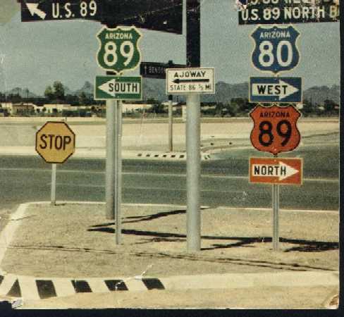
When I was in Phoenix a couple of weeks ago, I managed to grab these two shots with the cell phone camera. The blue shields are on US 60 as you approach Loop 101, the Agua Fria Freeway. Then at the point you turn onto the entry ramp, there is a white shield. THIS SITE says the blue ones are being phased out. In any case, I found this to be in interesting piece of road geekery.
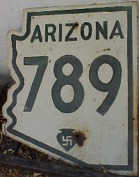
 Arizona also has the distinction of having once had a swastika on its state highway shields (CLICK HERE for an example). These were changed out during the 1940s and 1950s after the ancient symbol (used by the Hopi tribe of American Indians) was used by the Nazis in Germany under Adolph Hitler.
November 1, 2008
States To Which I Have Been
 I have enjoyed traveling to many parts of the United States, and find something I like everywhere I go. So for grins, I decided to color code a map of our fifty United States of America. The code is as follows:
Green - States where I have lived for at least a year
Purple - States where I have lived for less than a year
Blue - States I have been to
Yellow - States I have flown over, but not been to on the ground
Red - States I have yet to visit or traverse by air
September 10, 2008
Philippi Covered Bridge

West Virginia Historic Marker for the Philippi Covered Bridge.
Barbour County Sheriff's vehicle is approaching the bridge in the background
During my recent trip to West Virginia, I got to take in some historic sites. One afternoon the Lovely Spouse, her lovely mother, and I took a little drive south from Grafton to Webster and Philippi (pronounced "FILL-uh-pee"). This town is rich in history from the Civil War era. The line of loyalty to the Union or the CSA was between Philippi and Grafton, 20 miles to the north.
Philippi holds the distinction of being the location of the first land battle of the Civil War (with Ft. Sumter, SC being the first sea-based battle). The state of West Virginia owes its existence as an entity to that war, as it was created from loyalist counties in what was the western part of Virginia. In any case, the highway between Grafton and Philippi parallels the Tygart Valley River, and today carries US highways 119 and 250. In 1861, this was the main route south to Richmond, Virginia. Troops from both sides had encampments along the road, and one of the rail lines that runs beside it was a major transportation line even during the war.
The covered bridge at Philippi was used during the Civil War, and today is part of US highway 250. It is also one of the longest covered bridges in the United States, and is the only double-barreled covered bridge carrying traffic of a major federal highway.
As an additional note, three of the miners who died in the 2006 Sago Mine Disaster were from Philippi.

A side view of the Philippi Covered Bridge

View of one end of the Philippi Covered Bridge
September 1, 2008
Road Trip - Morgantown to Washington
Here is some fodder for all you fellow road geeks out there. This is my trip last Saturday from Morgantown, West Virginia to Reagan Washington National Airport, a distance of about 220 miles or so. I put these in a slide show, since there are over 170 pictures. All but a few of these were taken by the Lovely Spouse as I drove the rental car. She did a rather good job, I'd say. She may be getting in touch with her inner road geek. She took over 400 pictures and these are the cream of the crop. When she was having trouble with my Olympus E-500, I told her that she was no Jimmy Olsen with a camera, but after reviewing these, I think she may just be better than Jimmy.
Note: The slide show plays rather fast, so you may want to pause each picture to have time to read the captions. Or it may be easier to go directly to the album by clicking on the link below, where you can take your time with each picture. Either way, enjoy!
Note: The slide show plays rather fast, so you may want to pause each picture to have time to read the captions. Or it may be easier to go directly to the album by clicking on the link below, where you can take your time with each picture. Either way, enjoy!
 |
| Morgantown to Washington |
August 31, 2008
So Many Captions, So Little Time
 Well, it's back in Colorado tonight after a drive from West Virginia to Washington, DC; followed by a flight back to Denver International Airport. We got LOTS of road geekin' photos that I will be processing and posting, but this one that was taken this afternoon, cannot wait.
This sign is on the George Washington Parkway in Suburban Virginia across the Potomac from Washington. The humor is obvious, and there are so many possible captions. It is truly oxymoronic to see the name George Bush and Intelligence mentioned on the same sign! Even though I am sure this is named for the current Decider-in-Chief's father, it was too good a photo to let get away.
August 28, 2008
A Maryland Road Trip
Last Saturday after landing at Reagan National on the Virginia side of the Potomac near downtown Washington, we rented a car and started our trek to the home of the lovely spouse's parents. Our journey took us up the George Washington Parkway; the Washington Beltway (I-495) for a short distance; then up I-270 to I-70 to I-68 west to Morgantown, WV; then US 119 south to Grafton. As I was driving, the LS became my photographer for some of the photos, all the while saying she doesn't know how to use my camera. Still, we got some decent pictures, a few of which I have prepared to show here. Click on any of them to see a larger version.
The pictures start on 270 North. This highway was once I-70S before the powers that be began to eschew numbers and letters for numbering Interstate Highways, a stance I agree with. One noticeable thing is that Maryland is using some pretty big reassurance shields on this stretch of highway. There is also a stretch of I-270 in Denver, running between i-70 near Aurora and I-25 and US 36 (Boulder Turnpike).

The next photo is at Exits 10 & 11, and displays good examples of the Maryland state highway shields. One thing that 270 has is inner express lanes with exits to outer local lanes. The express ones have exits only every several regular exits. The local lanes are where traffic can get on and off the highway without slowing down the express lanes. An oddity on this particular sign is the mixed font sizes used.

As we approach the end of I-270 at I-70, the last exit before the merge is Exit 31B, Maryland 85 South to Buckeystown.

In advance of the I-70 junction, we see that the main lanes of I-270 will continue northward as US 15, on the Frederick, Maryland and Gettysburg, Pennsylvania. We can exit and go east on I-70 to Baltimore, or west to Hagerstown.

As we approach the exit, we get to the gore point, and are in the proper lane to merge onto I-70 West.

Once on the exit ramp, we get to another decision point.

From here, we travel west through Hagerstown. As we get close to the eastern terminus of I-68, we get advance notice of its exit. The alternate route west is an free alternative to staying on I-70 to the Pennsylvania Turnpike.

A little bit farther down the road, and we have a giant-sized trailblazer for I-68.

And getting closer to the start of 68 . . .

Now we are at narrowest point in the state of Maryland. Here the Mason-Dixon line where Pennsylvania and Maryland touch almost cuts Maryland in two, since the Potomac River is close to the south. Here is the last I-70 exit in Maryland. We will be taking it toward Cumberland.

Here is the actual exit. As you can see, US 40 is duplexed with I-68. As this is the eastern terminus of I-68, you can also see my photo of the western end of this highway taken last November, by CLICKING HERE.

And here is the first set of I-68 / US 40 reassurance shields. This freeway largely replaced old US 40. When it was first built, it was new US 40, then it was designated as US 48 from 1975-1989, and finally gained Interstate status as I-68. There is now a new US 48, which runs between I-81 and I-79 in Virginia and West Virginia. I still recall vividly how old US 40 ran through the Western Maryland mountains and that it took quite a while to get to and from Cumberland. This new road, also known as National Freeway, opened up a vital link to both Cumberland and Morgantown.

Maryland Wildlife . . . deers and bears...oh my!

Here is a mileage sign on 68. People sometimes don't believe there is a town called Flintstone. Here is the proof.
"Flintstones. Meet the Flintstones. They're the modern stone age family!"

The next shot shows Sideling Hill straight ahead, complete with the cut through for the highway visible to the left side of the picture.

Now, we are approaching the cut through Sideling . . .

Sideling Hill Cutout below. Old US 40 used to run about a mile or so toward the south, reach the summit, and come back to the north as it winds its way down. This cutaway reduced travel time significantly, and gave a four-lane freeway alternative to the two-lane, winding road. This is the eastern face of Sideling Hill, which is in Washington County. The opposite side is Allegany County. The building on the right of the freeway is a visitors center, with information about attractions in the area, as well as a history of the road cut. I have never seen a center dedicated to a cut through a mountain before, but here is one. Somewhere in Maryland, road geekdom must prevail!

As we get to the bottom of the other side, we cross Sideling Hill Creek and find an official MDoT Allegany County line sign.

And following that, is a fancier sign welcoming you to Allegany County.

Old US 40 is MD 144 as we get into the Flintstone area.

Cumberland city limits!

As we approach the heart of Cumberland, the county seat of Allegany county, we approach the Hillcrest Drive exit. Allegany County, Maryland is pronounced the same as Allegheny County, Pennsylvania (home county of Pittsburgh), but is obviously spelled differently.

Now we are at Exit 43C, which we will take into Downtown Cumberland to meet up with my friend Bob on our way to my in-laws. Bob and I worked together in radio back in the 1970s right here in Cumberland.
 ,
,
August 24, 2008
Cumberland Byways & History

A West Virginia highway trailblazer sign in Maryland
Cumberland, Maryland sits along the Potomac River, and the other side is a piece of land that is in West Virginia, and juts nearly into the heart of downtown. When I lived there, WV 28 came up a very narrow road on the edge of a tall hill, and many accidents occurred along the stretch. Ultimately, that stretch between Ridgeley and Fort Ashby were re-designated as Alternate WV 28, and the main highway was diverted to South Cumberland at Fort Ashby, ultimately crossing into Maryland near the Cumberland Airport.
The picture above was taken on Greene Street, which is the routing of US 220 through the west part of Cumberland. You will notice that although the sign is in Maryland, it is a West Virginia highway sign. I examined the back of the sign to see if it was a MDOT or WVDOT sign, but there were no asset labels on it.
A few feet away is the next sign, which gives directions to various highways in the area. Again, a WV highway shield is indicated, and is correct. There is also an I-68 shield on this sign. Interstate 68 extends from Hancock, Maryland at I-70, and goes west through Cumberland, Frostburg, and Grantsville, before entering West Virginia and terminating at I-79 in Morgantown.

Directional sign on Greene Street (US 220), Cumberland
If you look to the right at the traffic signals in the photo above, you will see the so-called "Blue Bridge" that spans the Potomac and connects Cumberland to Ridgeley, WV.

The Blue Bridge
Once you go across the Blue Bridge, you are in Mineral County and the town of Ridgeley, West Virginia. Looks like they did carry through with getting rid of the silly "Open for Business" signs I blogged about last year.

Welcome to Ridgeley, West Virginia
Ridgeley used to have a sign that speed limits are "Electriclly Timed", and it was indeed misspelled like that. At least that sign has been removed. When I first met the lovely spouse back in 1973, she was a high-school student who lived just outside the Ridgeley town limits on the south end of town. In the distance of the picture above, you can see a West Virginia historical marker. A closer look below shows that this was the site of Fort Ohio prior to the American Revolution, and the completion of Fort Cumberland back across the river in Maryland.

Fort Ohio Historical Marker in Ridgeley
Walking back over the Blue Bridge to Cumberland, I got a nice picture of the clouds and trees reflected in the waters of the Potomac.

Potomac River between Cumberland & Ridgeley
Another place of historic interest at this juncture of river, roads, cities, and states. On the Maryland side of the Blue Bridge is a small cabin that served as headquarters to General George Washington during the French & Indian War, and again as United States Commander-In-Chief. Fort Cumberland sat on a hill diagonally across the street from Washington's headquarters. Today's city of Cumberland derives its name from that fort. A church now sits on the hill, and is noted as a part of the famed Underground Railway that helped slaves escape from servitude prior to the American Civil War. In this part of the country, there is history all around us.

George Washington's Cumberland Headquarters
August 2, 2008
New Speed Zone Warning Signs
 Last April while driving to Houston from Colorado, I noticed a new type of warning sign. These were placed along US 287 just before coming into various towns along the highway. Rather than the rectangular white signs proclaiming Speed Zone Ahead, or Reduced Speed Ahead, Texas has placed diamond-shaped yellow warning signs with a standard speed limit sign and an arrow in their place. I found these to be much more helpful than the older signs that gave no idea how much you had to slow down.
I have since learned that these signs are part of a new standard outlined in the MUTCD, or Manual on Uniform Traffic Control Devices published by the Federal Highway Administration of the Department of Transportation. The states have until 2018 to fully deploy the new signs.
Uniform road signage is important to safety, as drivers can readily recognize and act upon information relayed by the signs. Imagine if you were driving from state to state, and every jurisdiction has their own sign conventions and designs. It would be pretty confusing, wouldn't it? This is why the MUTCD is important.
So anyway, back to the new speed zone warning signs. I noticed them popping up on Interstate 25 in Denver. There is also this one that I took a picture of today on Park Avenue in Downtown Denver. Behind the sign is Coors Field, home park of the Colorado Rockies baseball club.
Below is an image from the MUTCD that gives specifications for these new signs. This is one innovation that actually improves upon the status quo.

Subscribe to:
Posts (Atom)